JPL MEaSUREs:
Making Earth System Data Records for Use in Research Environments
NASA’s MEaSUREs Program; “NASA, through its Earth Science Data Systems (ESDS), supports the NASA Earth Science research community in providing Earth science data products and services driven by NASA’s Earth Science goals. NASA’s Earth Science Program is dedicated to advancing Earth remote sensing and pioneering the scientific use of satellite measurements to improve human understanding of our home planet in order to inform economic and policy decisions and improve operational services of benefit to the Nation. Through the MEaSUREs Program, NASA is continuing its commitment to expand understanding the Earth system using consistent records.” The MEaSUREs projects listed below have Principal Investigators from JPL.
-
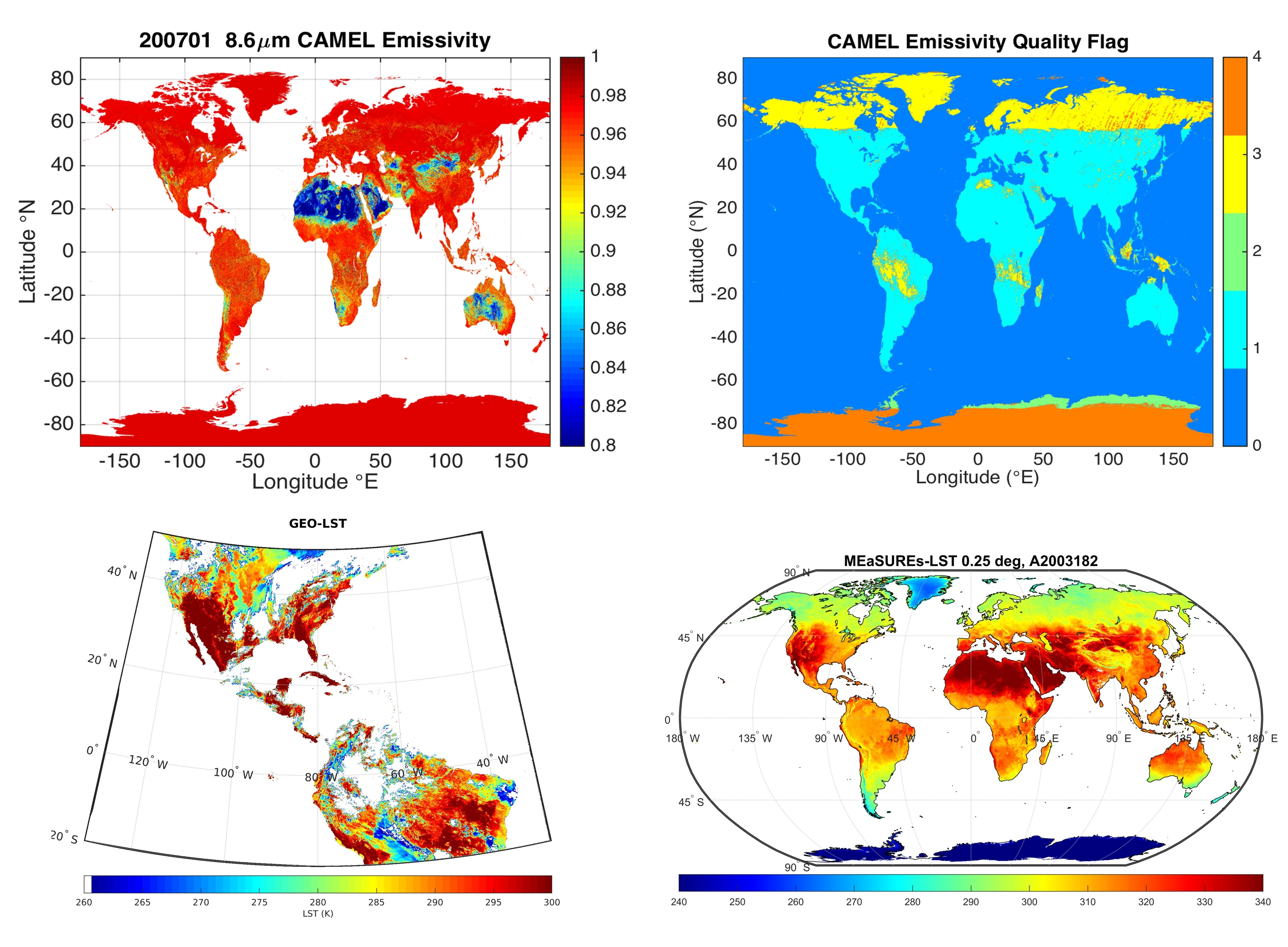
A Unified and Coherent Land Surface Temperature and Emissivity (LST&E) Earth System Data Record (ESDR) for Earth Science
The LST&E MEaSUREs project integrates different LST&E data streams from low earth orbit (MODIS, ASTER) and geostationary (GOES) observations to develop a unified set of LST&E earth system data records including uncertainty statistics. The long-term, climate quality LST&E data records provided from this project are critical variables for monitoring the long-term effects of climate change and studying a variety of Earth surface processes and surface-atmosphere interactions such as evapotranspiration, surface energy balance and water vapor retrievals.
-

Multi-decadal Time Series of Vegetation Chlorophyll Fluorescence and Derived Gross Primary Production
A long term, harmonized time series of Solar Induced Chlorophyll Fluorescence (SIF) is being produced as an Earth System Data Record for the MEaSUREs Program. SIF data offer a more direct way to measure photosynthetic activity in plants globally from space. This project blends together datasets from multiple satellites into a consistent, 25-year record spanning the period 1996-2020.
-

Records of Fused and Assimilated Satellite Carbon dioxide Observations and Fluxes from Multiple Instruments
Numerous existing sensors measure concentrations of carbon dioxide (CO2) in the atmosphere. Many of these sensors like Orbiting Carbon Observatory-2 (OCO-2), Greenhouse Gases Observing Satellite (GOSAT) and Atmospheric Infrared Sounder (AIRS) provide global scale observations, but these observations are oversampled in some locations and under sampled in others. By contrast, contiguous, global fields fused from multiple instruments would be useful to the scientific community. As part of this effort fused and/or gap-filled Earth System Data Records (ESDRs) of CO2, concentrations are being created by integrating observations from the Atmospheric CO2 Observations from Space (ACOS) retrievals of GOSAT, OCO-2 and AIRS. These ESDRs consists of not only fused column averaged CO2 (XCO2) but also complementary 3- dimensional fields like time stamps, location information, averaging kernels, prior mean profiles, pressure levels, uncertainties, and error covariance matrices to facilitate their incorporation in CO2 flux Data Assimilation systems.
https://disc.gsfc.nasa.gov/datasets/OCO2GriddedXCO2_3/summary
https://disc.gsfc.nasa.gov/datasets/MultiInstrumentFusedXCO2_3/summary
https://disc.gsfc.nasa.gov/datasets/OCO2GriddedXCO2_SIF_4/summary
-

A Long-Term Consistent Multi-Satellite Soil Moisture Data Record
This NASA MEaSUREs investigation focuses on the development of a long-term soil moisture data record based on decades of passive microwave observations acquired by spaceborne radiometers. Many of these radiometers operate at multiple frequency bands, but two particular frequency bands -- X-band (10.7 GHz) and L-band (1.4 GHz) -- form the majority of passive microwave observations that are suitable for soil moisture estimation. In this investigation, we will focus on soil moisture estimation based on brightness temperature (TB) observations acquired by various satellites at X- and L-band frequencies.
-

Cloudy Boundary Layer: A Climatology from Space
A MEaSUREs Cloudy Boundary Layer Data RecordA new multi-sensor multi-parameter Earth System Data Record of state of the art observations of the cloudy boundary layer was created as part of the MEaSUREs Program. This data record is intended to help better understand the physics of the cloudy boundary layer from a global perspective, and for the evaluation of models of varying complexity from simple bulk models to fully coupled global models. This project is focused on four key variables: boundary layer water vapor, liquid water path, boundary layer height and light surface precipitation.
https://climatesciences.jpl.nasa.gov/projects/cloudyboundary/
-

Multi-Sensor Ultra-high Resolution (MUR) SST Field
Mapping sea surface temperature (SST) from satellite measurements and surface observation (ship an bouy data). SST data are useful for weather forecasting, fisheries management, ocean acoustic communication, and scientific studies of climate and marine life.
-

GOZCARDS: Global Ozone Chemistry And Related trace gas Data records for the Stratosphere
The Global Ozone Chemistry And Related trace gas Data records for the Stratosphere (GOZCARDS) MEaSUREs project provides stratospheric composition data from Earth system data records. The science focus of this data includes ozone decline and recovery. High-quality long-term ozone and related trace gas data records are needed to (a) evaluate and understand composition changes in the atmosphere and (b) constrain model representations of atmospheric dynamics and photochemistry.
-

MEaSUREs Gridded Sea Surface Height Anomalies Version 2205
This dataset provides gridded Sea Surface Height Anomalies (SSHA) above a mean sea surface, on a 1/6th degree grid every 5 days. It contains the fully corrected heights, with a delay of up to 3 months. The gridded data are derived from the along-track SSHA data of TOPEX/Poseidon, Jason-1, Jason-2, Jason-3 and Jason-CS (Sentinel-6) as reference data from the level 2 along-track data found at https://podaac.jpl.nasa.gov/dataset/MERGED_TP_J1_OSTM_OST_CYCLES_V51, plus ERS-1, ERS-2, Envisat, SARAL-AltiKa, CryoSat-2, Sentinel-3A, Sentinel-3B depending on the date, from the RADS database. The date given in the grid files is the center of the 5-day window. The grids were produced from altimeter data using Kriging interpolation, which gives best linear prediction based upon prior knowledge of covariance.
https://podaac.jpl.nasa.gov/dataset/SEA_SURFACE_HEIGHT_ALT_GRIDS_L4_2SATS_5DAY_6THDEG_V_JPL2205