Tower: SIF, GPP, and Met Data
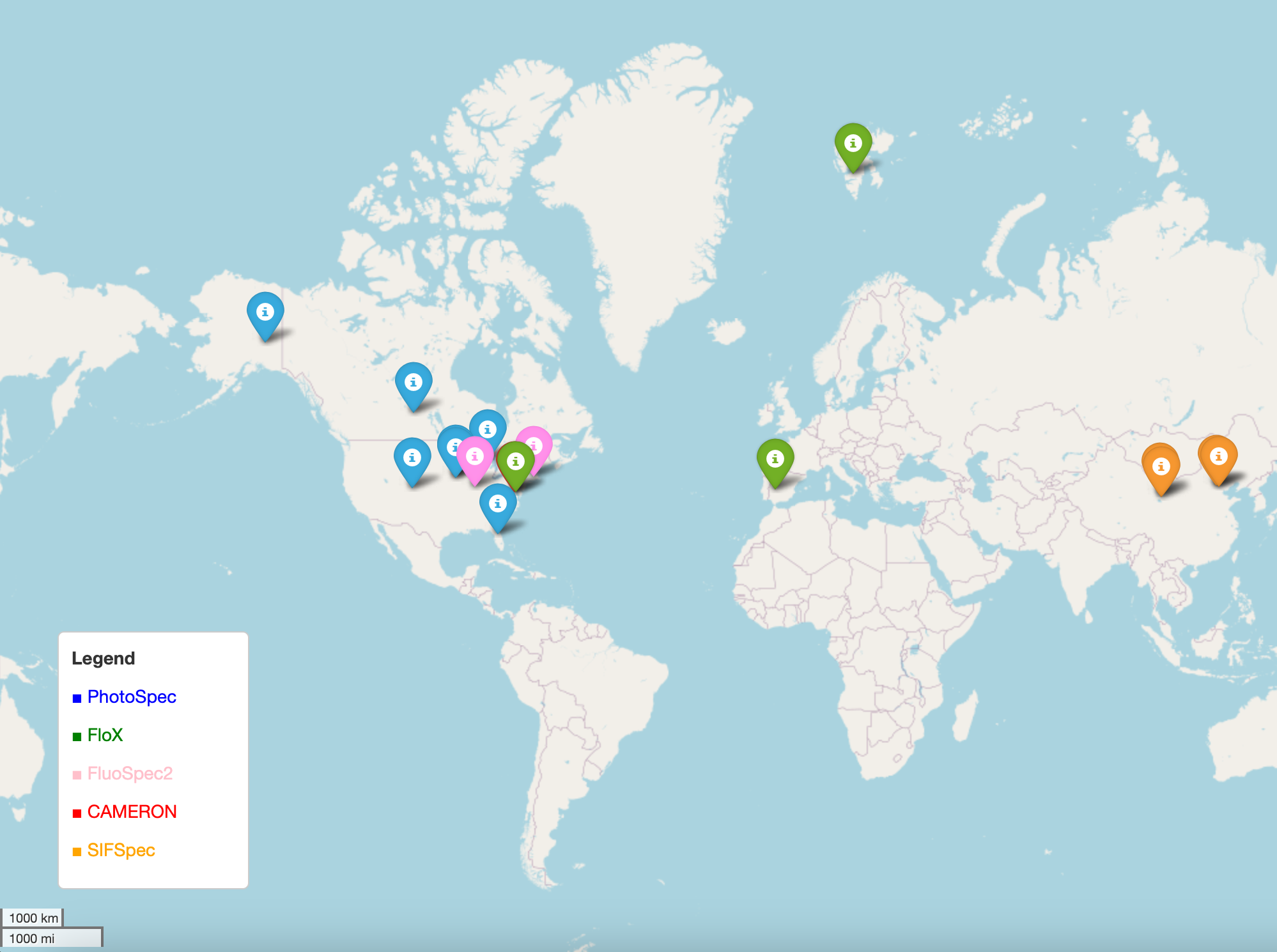
Global map of publicly available tower-scale SIF datasets. View an interactive version of this map here: Interactive Map and more information on displayed sites, including data access here: Proximal SIF data
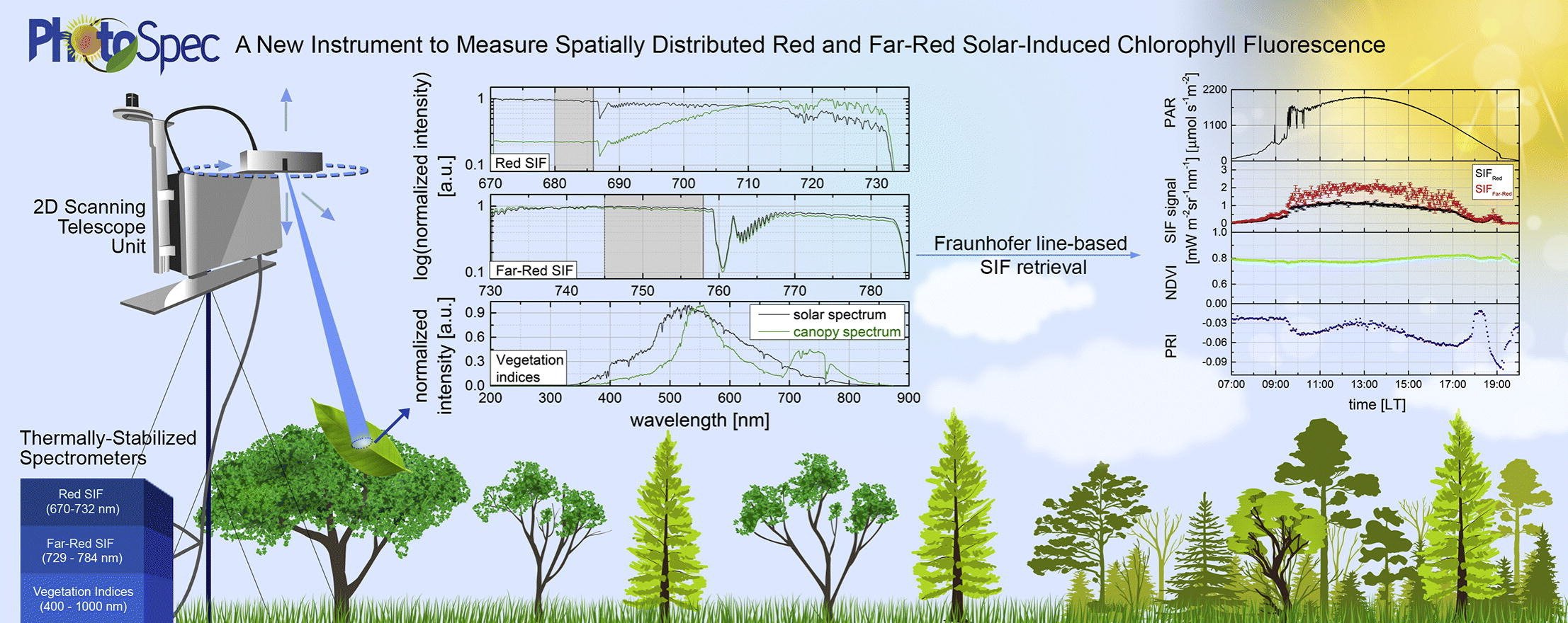
PhotoSpec
PhotoSpec is a ground-based spectrometer system that measures spatially distributed Solar-Induced Chlorophyll Fluorescence in the red (670-732 nm) and far-red (729–784 nm) wavelength range. Photospec also measures canopy reflectance (400–900 nm) to calculate vegetation indices such as the normalized difference vegetation index (NDVI), the enhanced vegetation index (EVI), and the photochemical reflectance index (PRI). PhotoSpec includes a 2D scanning telescope unit which can be pointed to any location in a canopy with a narrow field of view (FOV=0.7°). PhotoSpec has a high signal-to-noise ratio and spectral resolution, which allows high precision solar Fraunhofer line retrievals over the entire fluorescence wavelength range under all atmospheric conditions using a new two-step linearized least-squares retrieval procedure.
Data Access
Here is an overview of existing publicly available site-level SIF datasets. This list was last updated as of January 22 2024 and may be incomplete. You can help us out by contributing information on publicly accessible site level SIF data here or emailing Zoe Pierrat at zoe.a.pierrat@jpl.nasa.gov
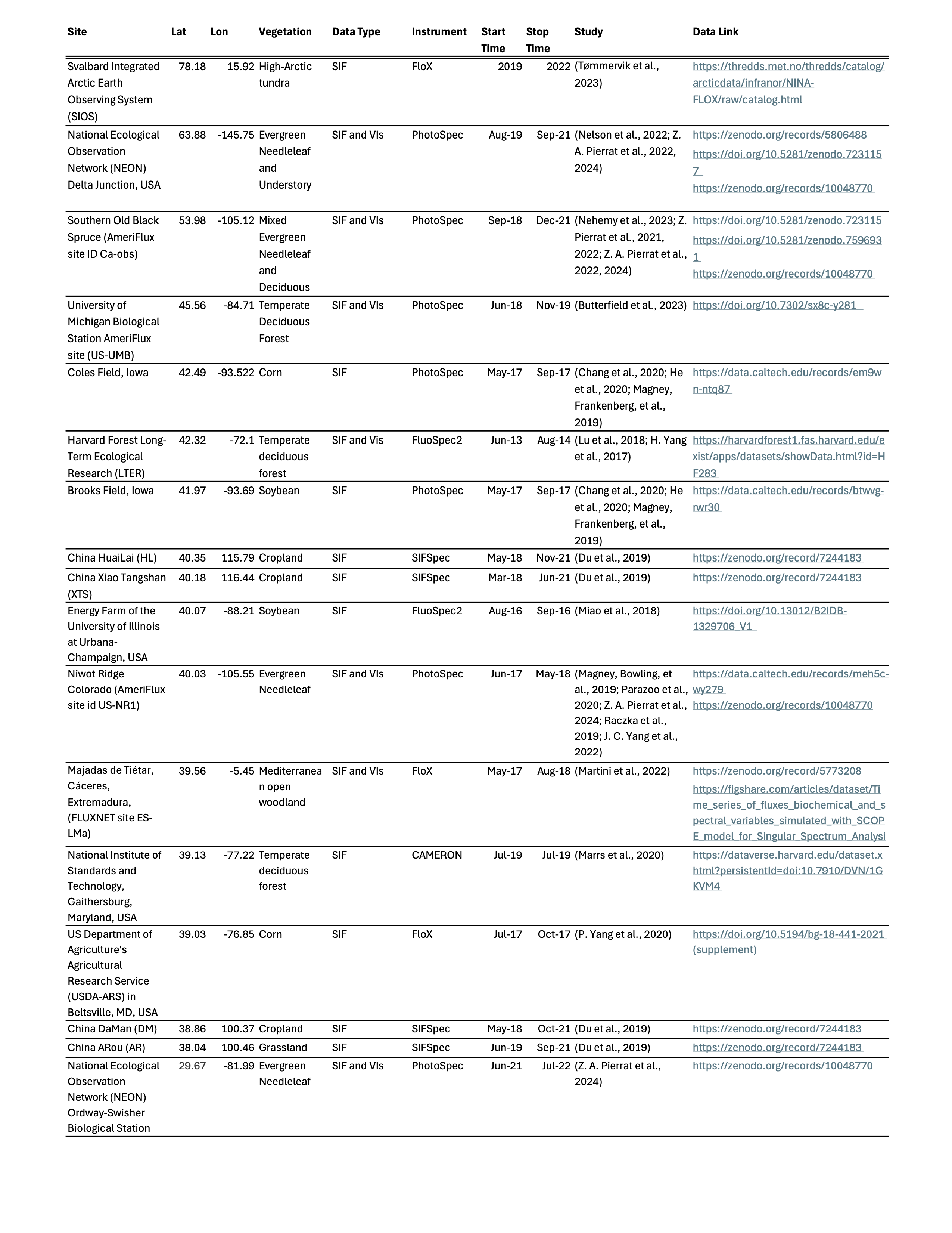
Overview of existing publicly available site-level SIF datasets. An excel version of this table with clickable DOI links can be found here: Proximal SIF data
PhotoSpec instruments are typically installed at eddy covariance (EC) towers to explore the relationship between SIF, Gross Primary Productivity (GPP), and other vegetation properties.
Delta Junction: Daily mean canopy scale SIF, vegetation induces (NIRv, NDVI, PRI, CCI), and PAR at black spruce dominated forest at the NEON Delta Junction site in Alaska, USA (DEJU, 64.65°N, 146.04°W) from August 2019 through December 2020
Southern Old Black Spruce: 30 minute canopy scale SIF, vegetation index (NIRv, NDVI, PRI, CCI), PAR, APAR, and fesc at mixed black spruce and larch site in Saskatchewan, Canada (OBS, 53.98°N, 105.12°W) from September 2019 through December 2020
Niwot Ridge: 60 minute canopy and needle scale SIF, EC, and meteorological data at the evergreen needleleaf forest (ENF) at Niwot Ridge, Colorado, USA (NR1, 40.03°N, 105.55°W, 3050 m elevation) from June 2017 through May 2018
Iowa Corn: 30 minute canopy scale SIF, EC, and meteorological data at corn field in central Iowa, USA (Coles Field, 42.49°N, 93.53°W) following planting in late May 2017 until harvest in September 2017
Iowa Soy: 30 minute canopy scale SIF, EC, and meteorological data at soy field in central Iowa, USA (Brooks Field, 41.97°N, 93.69°W) following planting in late May 2017 a until harvest in September 2017