Satellite: Level 2 SIF
Gridded and ungridded satellite SIF datasets are saved in two forms: Research and Archived. Research Products are meant to be temporary and are subject to frequent updates. Archived data are more permanent and come with DOI's. Archived datasets distributed at DAAC's and DISC's come with additional tools and services enabling visualization and manipulation.
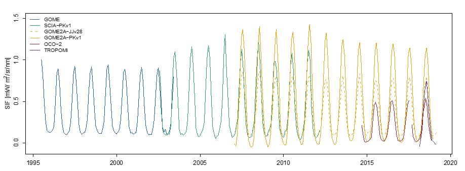
MEASURES Products
- GOME V1: 1996-2003
- Derived from the Global Ozone Monitoring Experiment (GOME) instrument on the European Space Agency's (ESA's) European Remote-Sensing 2 (ERS-2) satellite from July 1995 to December 2003 (Joiner et al., 2019)
- SCIAMACHY V1: 2003-2012
- Derived from the SCanning Imaging Absorption spectroMeter for Atmospheric CartograpHY (SCIAMACHY) instrument on the European Space Agency's (ESA's) Environmental satellite (Envisat) satellite from January 2002 to April 2012 (Joiner et al., 2021)
- GOME-2A V1: 2007-2018
- Derived from the GOME-2 instrument on the European Meteorological Satellite (EUMETSAT's) MetOp-A satellite from February 2007 to January 2018 (Joiner et al., 2022)
Archived Data
GSFC DISC: SIF Lite Products
- GOSAT: 2010 - present
- OCO-2: 2014 - present
- OCO-3: 2019 - present
- Poster Describing Harmonized Lite Products
CalTechDATA
- TROPOMI (far-red): 2018 - present
Research Products
- SCIA-PKv1: 2003-2012
- GOME2A-PKv1: 2007-present
- GOSAT: 2009-2016
- OCO-2: 2014-present
- TROPOMI (far-red): 2018-present
- TROPOMI (red): 2018-present
- GOME: 1996-2003
- SCIA-JJv28: 2003-2012
- GOME2A-JJv28: 2007-present
- GOME2B: 2013-2021
ESA S5P-PAL TROPOSIF (informational only)
- L2 SIF: May 2018 - Present (1-4 week latency)